Boston is moving ahead with plans to address rising sea levels predicted as a result of climate change, using designs by New York firm SCAPE.
The Resilient Boston Harbor landscape and urbanism initiative appointed SCAPE to help improve the city's coastal defences in preparation for the effects of a warming climate.
Alongside consulting firm Arcadis and Massachusetts firm Nitsch Engineering, the landscape architecture and urban design studio will work with the City of Boston to deliver.
The goal of the Resilient Boston Harbor project is "to guide open space investments toward more resilient and accessible communities", according to a statement from SCAPE.
It will increase access to Boston's 47-mile shoreline and waterfront, while better protecting the area from flooding with infrastructure.
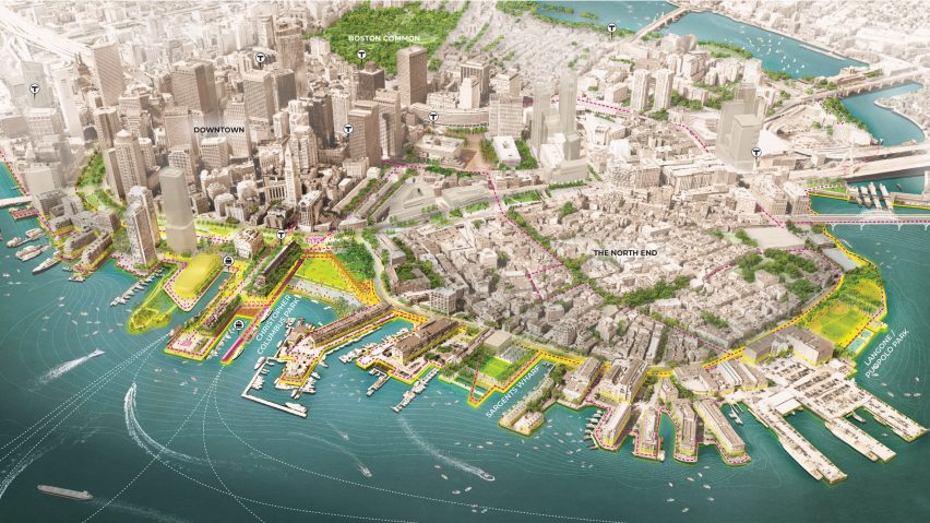
A selection of at-risk buildings will be raised and flood-adapted, while a series of elevated landscapes, pathways and protective parks will be constructed along the low-lying shore.
Diagrams from SCAPE depict these features in lime green, with connections to existing infrastructure marked in pink.
"This series of drawings reveal how ongoing neighbourhood planning efforts could be stitched together with a new layer of parks, boulevards and recreational spaces that help absorb rainwater, buffer from storms, and connect all of Boston to more park and waterfront assets," said the statement.
SCAPE has divided Boston into four main areas to tackle the plan: Downtown, South, East and Dorchester. Smaller neighbourhood initiatives were then developed for each section.
For Downtown Boston and just north of the city, "resilient" waterfront parks are to be created in order to protect the area from flooding, as well as provide gateways to the harbour.
Specific areas addressed Downtown are Christopher Columbus Park, Langone Puopolo Park, and Sargent's Wharf.
Another set of diagrams of a worst-case scenario show a significant amount of Boston underwater by 2070, based on a sea-level rise of 40 inches (one metre) during a storm with a one per cent annual chance.
For East Boston, waterfront parks will be redesigned to enhance flood protection, and improve access and recreation facilities. Restored marshes at Belle Isle will buffer the shoreline from waves and storm surge.
In South Boston, where a protective border is planned at Moakley Park and a re-envisioned Fort Point Channel, both which will also work together to block major flood pathways.
For the shoreline farther outside Boston, including the Dorchester area and Malibu Beach, plans are to expand beaches and to create better access to the waterfront.
"This vision aims to anticipate change and is a first step in that open change process, signalling an intent to meet the challenge and a collaborative method to provide solutions," said SCAPE.
In addition to the Resilient Boston Harbor plan, mayor Martin J Walsh announced on 19 October 2018 that the city plans for all Boston residents to have a park within a 10-minute walk from home.
Proposals to tackle the effects of climate change been released for several major coastal cities in America, including schemes for New York City and San Francisco – both of which involve architecture firm BIG.
Images are by SCAPE and the City of Boston.

